Wednesday, June 29, 2011

Biking, birding, and a blast from the past

A view of the Sustrans bike path south of Paisley
Sustrans National Cycle Route #7 - close to Lochwinnoch
June 16 was another bright and friendly day in Scotland. Mike and I decided to ride out to visit the RSPB (Royal Society for the Preservation of Birds – we are now members) nature reserve at Lochwinnoch and then push on to Kilbirnie. These are both on the Sustrans National Cycle Network route #7 running south west from Glasgow. We ended up riding 88 km all told – our longest ride yet on this trip.

The day was perfect for riding – not too hot, warm enough for shorts, breezy, but not a wicked wind, and, of course, we were on a traffic-free bike path for most of the way. Paisley and a full Scottish (for those of you not in the know this means breakfast consisting of ALL of the following: eggs, aryshire bacon, sausages, black pudding, potato scone, grilled tomato, and baked beans) was the first order of the day. From here it was on to Lochwinnoch followed by the town of Kilbirnie.

Just after Paisley we diverted off the bike path in the town of Elderslie to see the William Wallace Monument. I’m not talking about the famous one in Stirling – the Elserslie monument is much more human in scale and is part of an archaeological site. As well, Elderslie is considered by many to be the town in which William Wallace (1272 – 1305) was born.

Male Goldfinch
Male Goldfinch - RSPB Reserve
Most people can understand a fascination with a beautiful nature reserve like Lochwinnoch, but fascination with Kilbirnie, a town that was a victim of the Thatcher era and is still an unemployment “blackspot” today, might seem a bit odd. The explanation: Kilbirnie holds a place in memory for Mike and me. It was here that we first stopped for a pint on our 2007 biking tour of Scotland. The day was August 27th and we had only just flown into Paisley that morning. By the time we rolled into Kilbirnie we were thirsty travellers indeed!

IMG_4197
The closed bar in Kilbirnie - so sad, so thristy!
We pulled up to what looked like the only pub in town, parked the bikes on the wall outside the window and wandered in. What a classic working-man’s pub it was – dark, dusty, smelling of whisky, spilled beer, and stale cigarette smoke (no more smoking in pubs in 2007 – thank goodness!). We only just got our beer when a couple of old fellows engaged us in conversation about the death of the town. They had both worked in the big steel foundry that was the mainstay of the place. The spoke of their utter disdain for Margret Thatcher as if she was still a force in their lives. They spoke of spending time on the Isle of Arran, running up Goatfell, Arran’s big mountain, and growing up in a Scottish industrial town. It was a great introduction to Scotland away from the tourist track.

I guess Mike and I are pretty sentimental. Our ride to Kilbirnie was for old time’s sake – and to get another pint at that same pub. Unfortunately, the pub closed last year. But, the friendly reputation of Kilbirnie inhabitants was upheld by a fellow that saw us looking with sadness at the building that used to house the pub. He came over and gave us the full story on the demise of that particular drinking establishment.

We turned for home and had a delightful ride into the soft light of evening. We pulled into Glasgow at about 7:00 and headed to Sauchiehall Street, to Hengler’s Circus pub where we reminisced about past cycling glories and raised a pint to future rides in Scotland.
Two pints, two hands, and two bikes
Here's to more adventures!

Map of Sustran's National Cycle Route #7
More of Mary's Paisley and Lochwinnoch pictures.
More of Mike's Paisley and Lochwinnoch pictures.

Monday, June 27, 2011

The Cobbler + Two

On the trail
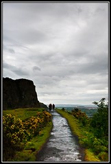
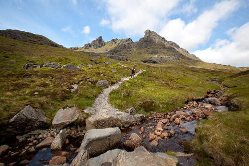
Mike on the trail up to The Cobbler
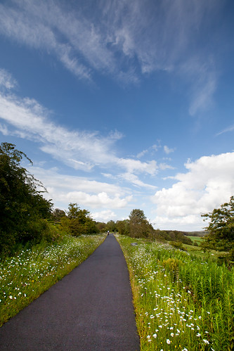
So far the month of June has not been overly generous with warm, sunny days. Whenever one presents itself, we grab it and go. On Tuesday, June 14, Scotland gifted us with just such a day, so off we went to the Arrochar Alps for a multi-peak ramble.

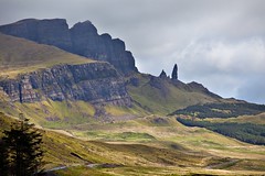
The Arrochar Alps are a group of mountains tucked into the land at the head of Loch Long, and close to the north west side of Loch Lomond. They are made up of a number of peaks (including four Munros – mountains over 3000 feet), but the summit that attracts everyone's eye is surely The Cobbler (aka Ben Arthur). This 884 metre (2900 ft) mountain is supposed to represent a cobbler working shoes at his last – but to me it looks like a Dungeness crab reaching up with its pinchers to catch the sun. It doesn't qualify as a Munro, but for sheer hill walking fun it is hard to beat. However, the day wouldn't be complete without a Munro or two, so after The Cobbler we did Beinn Ime and Beinn Narnain - 1011 m/3316ft and 926m/3038ft respectively.

Mike and I first glimpsed The Cobbler in Sept 2007 from the top of Ben Lomond and I have been lusting after it ever since. When we got down off the bus in the village of Arrochar the morning sun was just hitting the mountain. I couldn't believe my luck in having such a perfect day to fulfill my Cobbler-climbing dreams.

The Arrochar Alps contain some of the most southerly Munros and, with easy access from Glasgow, they can be heavily used. Such was not the case for our day in the hills - we saw only a few people, and all were very friendly. I don't know who makes and maintains the trails in this area, but they are in excellent shape, with large stone steps through areas that could easily become eroded mud-fests.

On the way up we came across two young fellows from the Paisley area (just south of Glasgow) who were out for a ramble in the hills - they were keen to talk about Bonnie Scotland, sports, life in other places, and Scottish politics. Over the day we chatted with several other adventurers, many of whom were much older and moving much faster than us!
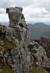
Argyll's Eyeglass
The Eyeglass
Approaching The Cobbler from the eastern corrie gave us ample time to gaze up at the interesting summit. Looking at the mountain you might think that the northern crag is the top, but not so. The actual summit is a small pinnacle of rock centred on the ridge between the two "pinchers". To access the true summit you climb through a small hole in the spire. This gap, called Argyle's Eyeglass, leads to a slightly pitched ledge edged with a sheer drop off. You take a few steps along the ledge to a spur of rock jutting out at right angles, scramble up the spur, lever on to the flat top and there you are - on the peak.

Mike on the ledge to the summit scramble
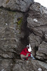
Mike on the summit ledge
Sadly, neither Mike nor I made the actual summit - both of us went out on the ledge and over to the spur. It did not look too difficult to get up, but I knew I would have trouble coming back down. For Mike's part, I'm pretty sure the only thing stopping him from going to the top was me -- because, if he made the summit, he knew I would surely have to try!
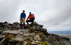
Mark and Mike on Ben Ime
On Beinn Ime
After a lunch stop on the northern crag we headed down to the bealach between Beinn Ime and Beinn Narnain. Ime was our next stop, and, after an easy, if somewhat sloggy and boggy ascent, we reached the top of our first Munro for the day. We were greeted by a group of Ramblers (a hill-walking club) who happily filled us in on mountains in the vicinity, and other routes of interest. At 1011 metres, Ime was our highest peak for the day. The views from up top were extensive – we could see Ben Nevis to the north, south to the Isle of Arran, and all through the West and Central Highlands.

We retraced our path back to the high pass bealach and then headed up Narnain. The top of this Munro is a broad plateau of schist, quartz, and mica. We took a rest, mugged at the cairn, and decided to head down off the east ridge. The ridge is a combination of steep fissures and rolling tops. It made for an interesting scramble in the golden light of early evening.

Mike surveys Loch Long and the evening view
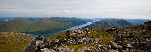
Evening views down Loch Long from Beinn Narnain
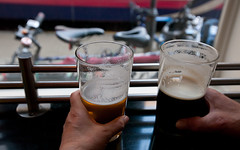
We regained our trail of the morning and headed down from the hills with chorus after chorus of skylarks singing us on our way. We got back to Arrochar village with just enough time for a quick pint at Ben Arthur’s Bothy. Then it was up onto the bus and away home to Glasgow.


View The Cobbler + Two in a larger map

More pictures from Mary of The Cobbler + Two
More pictures from Mike of The Cobbler + Two

Friday, June 17, 2011

Big Wheels and Great Tits: A biking and birding adventure in Scotland

Scene on the Forth and Clyde Canal
From the banks of the Forth and Clyde Canal
In the last few weeks Mike and I decided to get out on the bikes and travel some of the cycle paths on the Forth and Clyde Canal. This 56 km long waterway connects the River Clyde running through Glasgow with the Firth of Forth on the east coast (just above Edinburgh). There are excellent connections to the canal-side paths from the River Kelvin, which is about 200 metres from our flat.

On our first foray (June 2) we did a little jaunt to Speirs Wharf – an offshoot from the Forth and Clyde going into the heart of northern Glasgow. On June 4th we rode out to under the Erskine Bridge, just above where the canal meets the River Clyde. Our third excursion on June 9th was the longest – 87 km out and back to the Falkirk Wheel.

The Wheel is quite a feat of engineering. It is designed to lift boats from the Forth and Clyde to the Union Canal. The Union, which also has a bike path alongside, goes into the heart of Edinburgh. Boats sail in to a huge bathtub on one end of the Falkirk Wheel and get rotated up 35m/ 115ft into the air from the Forth and Clyde and sail out on the Union. At the same time as a boat is going up, another is coming down. It is really quite something to see the big Wheel in action.


Falkirk Wheel in action
The canals also make for some of the best wildlife habitat in Central Scotland – especially for birds. Some of you might recall that a few years ago back home in Victoria I was able to indulge in a season of NMT (non-motorized transport) birding with friends Jan and Alan. An NMT endeavour involves going out to look at birds via any completely non-motorized means – walking and/or biking are the usual transpo modes adopted. 

The Forth and Clyde Canal certainly has all of the NMT birding prerequisites – accessible biking, interesting birds, and lots of places to stop for a sustaining pint of ale. Mike, however, has admitted to finding bird watching a bit boring. I think he still can’t understand why this activity doesn’t actively involve admiring attractive ladies of the Homo sapiens species.

Great Tit - Closeup
Parus Major
Be that as it may, I believe Mike found his NMT metier on the Forth and Clyde – while stopped along the banks he zeroed in on a group of Great Tits. He was initially attracted by their interesting colouration and jaunty behaviour. Indeed, I was pleased to inform Mike that there are between 300,000 to 450,000 pairs in Scotland. And, due in part to good conservation of suitable habitat, the population has been increasing since the 1960s. So good was the canal-side viewing that I believe Mike is now able to recognize and correctly identify a Parus Major at 50 paces without the aid of binoculars – how many of you can say the same!

Of course, there is a pitfall involved in NMTing at this time of the year on Scotland’s canals – namely Mute Swans. More precisely, Mute Swans with young cygnets. We must have seen 10 families on our ride. One is, by the very nature of the canal tow-path, quite close to both parents and young. Several times (okay, maybe I was trying to sneak up for some cygnet photos) I was hissed and charged and had to beat a hasty retreat. I soon learned to stay well away and use the long lens for any baby pictures.

Hissing swans aside, all of our canal-side rides have rolled us serenely along through bucolic countryside, often with views over the surrounding hills. It seems hard to imagine that these waterways were ever the lifeblood of Scottish industry, teeming with barges, boats, and people on the move. Today life on the canal proceeds at a much slower pace – just perfect for two aging bicyclists. We will certainly return our wheels to the tow-path, all the while keeping our eyes peeled for Parus Major (now you all know the scientific name for Great Tits).

More of Mary's pictures from the canal path.
More of Mike's pictures from the canal path.
Map of the Forth and Clyde Canal and the Union Canal.

Wednesday, June 8, 2011

Another Fine Day in the Scottish Hills

Mike surveys the views
Mike takes in the view from the summit of Ben More
On Friday June 3, Mike and I enjoyed a walk in the mountains above Glen Dochart, and bagged two new Munros in the process. We climbed Ben More (1174 m / 3851 ft – the name means Big Mountain in Gaelic), Stob Binnein (1165 m / 3822 ft – pronounced Sto Binian – Anvil Peak ), and Stob Coire an Lochain (just below 1050 m – Stop Corr an Lochain – Peak of the Corrie Pond). The going was a bit stiff, especially the steep ascent on the northwest ridge of Ben More, but the day was sheer perfection.

Ben More and Stob Binnein are both Munros (Scottish mountains over 3000 feet), indeed they are the 16th and 18th highest in the country. Even though it is over 3000 ft, Stob Coire an Lochain doesn’t count as a Munro – it is a “Munro Top”. Not sure why this is – possibly because the ridge joining Binnein and Coire an Lochain is short and doesn’t really dip enough to clearly separate the two peaks. (In fact it is only ten minutes or so hiking between the two.)

Regardless of designation the views were outstanding – from the top of More we could see up to Ben Nevis in the north, the Isle of Arran and its high peak of Goat Fell in the southwest, and all the way to Edinburgh and the Firth of Forth in the East. From Stob Binnein we could see the Wallace Monument in Stirling. We spent the entire day gazing at rank after rank of imposing peaks, deep green glens, and blue lochs.

We began in the town of Crianlarich and walked out about two miles along a dismantled railway track. The old track kept us off the busy A85 highway, and put us right along the shores of Loch Dochart. Just past Benmore Farm we started our tramp up the hulking side of Ben More. It took us just over two hours to get from the base to the summit – a rise of just about 1000 metres in a distance of around 2 km.

After drinking in the view on Ben More we went down 300 metres to the saddle between More and Binnein – called a bealach in Gaelic. This one is named Bealach-eadar-dha-beinn (pronounced Byalach-aitar-gha-ben) which means “pass between two mountains” (sounds a lot more romantic in Gaelic). Then we regained almost all of those 300 metres as we went up the ridge to the top of Stob Binnein and along to Stob Coire an Lochain.

Mary resting at lochan
Mary taking a nap on Stob Coire an Lochain
Coire an Lochain was probably the most inviting of all the peaks because it had a small pond right at the top. Alongside this tiny lochan the springy heather was dry, the sun was warm, and the wind was light, so we indulged in a wee nap.

All good things must come to an end and soon enough we had to think about coming back down. I didn’t want to hump back up to the top of Binnein, so we contoured around the western side to come out just above the bealach. From here we went down the western slopes of Ben More into Benmore Glen.

Down in the glen we stopped to bath our feet in a quickly running stream – refreshed, rested, and with mountain-water-clean feet we tramped around the base of Ben More and retraced our steps back into Crianlarich. A wonderful meal and a few pints at the Rod and Reel Pub awaited us. Then it was up onto the bus and back home – another fine day in the Scottish hills.


Map of the route


View Ben More and Stob Binnein in a larger map


More pictures of Ben More and Stob Binnein from Mary
More pictures of Ben More and Stob Binnein from Mike

Thursday, June 2, 2011

Janice's Highland Fling


Cullin and Honeycomb Rock
Last week my sister Janice flew in from Canada and paid us a visit. I thought Mike and I were keen travellers, but we are mere pikers in comparison to her. In eight days Janice saw more of Glasgow than I have seen in a month, went hiking and castle-bagging on the Isle of Skye, toured Glen Coe, sailed on Loch Ness, rambled up Arthur’s Seat and down Edinburgh’s Royal Mile, and searched out tasty brews in each pub she entered (and she entered LOTS!). Mike and I did our best to keep up, but even Mike had to take a day of rest – I had to take two.

On the way up to Arthur's Seat
Path up Arthur's Seat
Our first foray outside of “The Dear Green Place” (Glasgow) had us on the bus to Edinburgh where we met up with Janice’s friends from Revelstoke BC. Kathy and Bob were in the UK on vacation. They had just finished walking the Coast To Coast hiking route in Northern England and wanted to see a bit of Scotland before heading home.

Kathy met us at the bus station in Edinburgh and we started to explore. All eyes turned to the hill in the eastern part of the town – Arthur’s Seat in Holyrood Park. The ridges and high points in the park are the remnants of a volcano that last erupted 340 million years ago. After a stop to let a cloudburst pass (this is Scotland after all), we started up. The group of us spent several hours poking around. After this it was down into the town for a walk up the Royal Mile and dinner at the End of the World pub.

Janice at Kilt Rock waterfall - closeup
Janice at Kilt Rock Falls, Isle of Skye
Next on the touring agenda was the misty Isle of Skye. We took the bus up and back (cost for three of us – there and back - £12.00 – the bus company was having a sale). We rented a car and toured for two days. Highlights were a hike on Elgol beach to see the Cuillin range rising out of the sea, Dunvegan Castle, home of clan MacLeod (yes Alan, we were thinking of you – the resemblance to some of the featured MacLeods is extraordinary!), and a hike up to The Old Man of Storr on the Totternish peninsula. Geology, history, and light made this a place Mike and I will return to for more adventures.

Old Man of Storr
Old Man of Storr
Janice left Glasgow on Tuesday, May 31st with some fine Highland experiences under her belt – she will soon have some pictures posted on her Flickr site – I’ll update this post as soon as she gets them in place (updated -- see the link below).

Mike and I enjoyed showing off our new “home”. We’ll be welcoming other visitors as the summer progresses. Hopefully they will enjoy themselves in the bonnie braes of Scotland as much as Janice did.

More pictures from our Edinburgh day here.
More pictures from our Skye rambles here.
More pictures from Janice here.