We have not yet come to blows, but the discussion often ends with a demonstration of navigational prowess -- we all have to align our walking sticks and poles along the ground towards True North. Then Alan hauls out a beautiful sterling silver compass and the winner is decided. Of course, this is considerably more challenging on an overcast day hunkered down under a rock outcrop.
Even though we don't have Jan and Alan for our summer rambles, we still carry on the tradition of going for the big views and discussing the possibility that yes, that could be Mt. Ranier on the horizon, and not just some cloud formation. Doesn't matter who we hike with, or what type of local knowledge they posses, tradition demands we engage in the "What mountain" discussion.
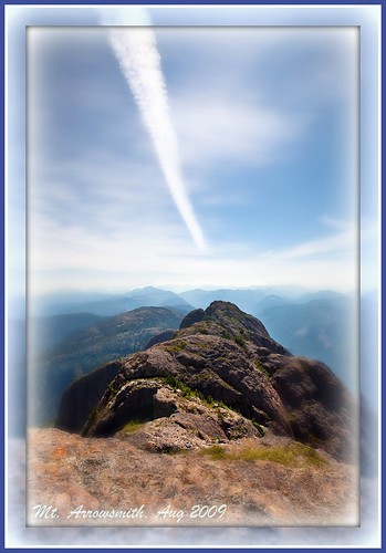
The picture here is from the summit of one of the largest chunks of basalt on Southern Vancouver Island -- Mt. Arrowsmith. It rises 1817 metres (5962 feet) over Port Alberni. The view here is looking south along the ridge of the massif. A huge, steep gully separates the us on the summit from the next hump along. Past that, the mountains extend off into the distance.
I bet on a clear day we could see the Olympic mountains in Washington. There was a great deal of pollution and haze in the air (a heat wave and no wind = ground level ozone and haze), so no crisp views.
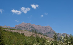
Mike and I, along with Tom (relatively new resident of Vancouver Island) and Rod (old friend from St. John's Newfoundland) went up the twists and turns of the Judge's Route. The trail is badly eroded in places and it was often easier to scramble up the adjacent rock faces then stay in the ruts of the trail.
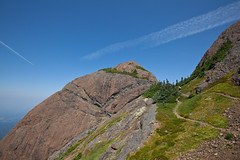
This is a fairly steep hike -- ascending 1 km of altitude in 3 km of trail. No need for ropes, but a helmet might be a safe idea. The views from the summit are worth every grunt and groan. On a clear day you can see right across Vancouver Island from east to west.
I think Mike and I will try to get back this year for a winter hike. Maybe a bit chilly, but the air should be crystal-clear and surely we'll be able to hold a really detailed discussion on "Which mountain is that".
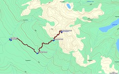
Check out our route on Google Maps:
The Judge's Route .
More pictures from our tramp up Mt. Arrowsmith: Our pics on Flickr .


0 comments:
Post a Comment