We started at TLC's parking lot above the Sooke Potholes, hiking along Mary Vine Creek to Peden Lake. We normally stop in at Peden to take a decko at the lake and cabin. I've heard that King Gentian Gentiana sceptrum can be found on the lake margins, and I was hoping to see some this trip. However, as we were getting close to the cabin two hikers came down the trail. They were part of a larger group camping at Peden. We didn't want to disturb them, so passed by without visiting the cabin.
Past the cabin turnoff we took in some views of Peden from a view point above the lake. We saw Stellar's jays and Flickers in the trees and lots of fish jumping -- it was a perfect "lake in the mountains" BC moment.
We then joined the "regular" route to the summit of Empress Mountain, going up the Todd Creek trail. We were soon on the summit approach and just as we got up out of the trees the marine cloud that had blanketed us all morning cleared off -- blue skies and long views waited for us up on top.
 |
| Summit of Empress Mountain |
I am so pleased the Land Conservancy and CRD parks were able to put together these wilderness jewels. The vista seems to belong together, with each peak rolling together into the next. Roads and development, no matter how well planned, would segregate and chop this area up into wilderness enclaves, separated from one another by "progress".
I know, I know -- much of this area is second growth, so it isn't as if the Sooke Hills have not known the hand of man. But, much of that logging was well over 50 years ago and the land has come back very well.
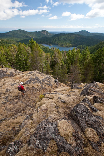
From the summit of Empress we went south over the Dumbbell Peaks. These two summits, joined by a high saddle poke up over the landscape like a dumbbell left on the gym floor. Although Mike had been here before, this was a "lifer" for Tom and me. The views, especially of Sheilds Lake, were outstanding.
Hiking the Dumbbells required about 150 metres of steep ascent through young Douglas Fir trees. Then we popped out onto the northern most Dumbbell summit. These rises are perfect examples of "balds" -- open, rocky areas where the vegetation is largely made up of grasses and mosses. The soil is very shallow and can't recover easily from disturbance. In the spring these balds are moist and green, supporting all sorts of wild flowers, Manzanita shrubs, Arbutus trees and Garry Oaks. By fall they have turned golden yellow as the mosses and grasses dry out.
Travel over these balds is delicate. We always try to hike on rocky areas and avoid dislodging the clinging mosses. Certainly this is no area for ATVs or other forms of motorized transport!
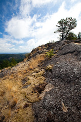
From the Dumbbells we crossed some rich salal draws and climbed up Puzzle Peak. Here the geology changed -- it was still basalt, but on Puzzle the basalt had formed into huge columns that seemed to fit together like ... well, pieces of a puzzle (okay -- at least that's what I assumed!).
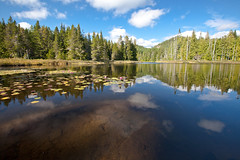 |
| Grass Lake in the later afternoon sun |
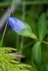 |
| King Gentian at Grass Lake |
The final adventure for the day was taking "the pipe" (the old water pipe) back to the car. Tom and Mike opted for that method of return, while I stayed on the Todd Creek trail, crossed the Galloping Goose, and ended up just outside the gates to the lower Sooke Potholes parking lot. I'll only say that I finished the hike 25 minutes before Tom and Mike -- and Mike actually fell off the pipe at one point.
I had my trusty Garmin GPS 60cx with me, so was able to make a reasonable map of the route -- I've included it below.
I very much recommend a ramble in this part of the Sooke Hills Wilderness. Even if you don't head out for the entire trip, a simple out and back to Peden Lake, or up and back to Grass Lake via the Harrison Trail will give you a good feel for the area. And, if you get too hot, you can always jump into one of the lakes and cool off with the snakes!
Sooke Potholes to Peden Lake, Empress Mountain, and Grass Lake
View Empress Mountain via Peden and Grass Lakes in a larger map


1 comments:
What a day! Wish I had been there - especially to see the snake. -- Jan
Post a Comment